


SEVERE WEATHER
To make it easier for our citizens to gather potentially life-saving severe weather information, we have made several items available below:
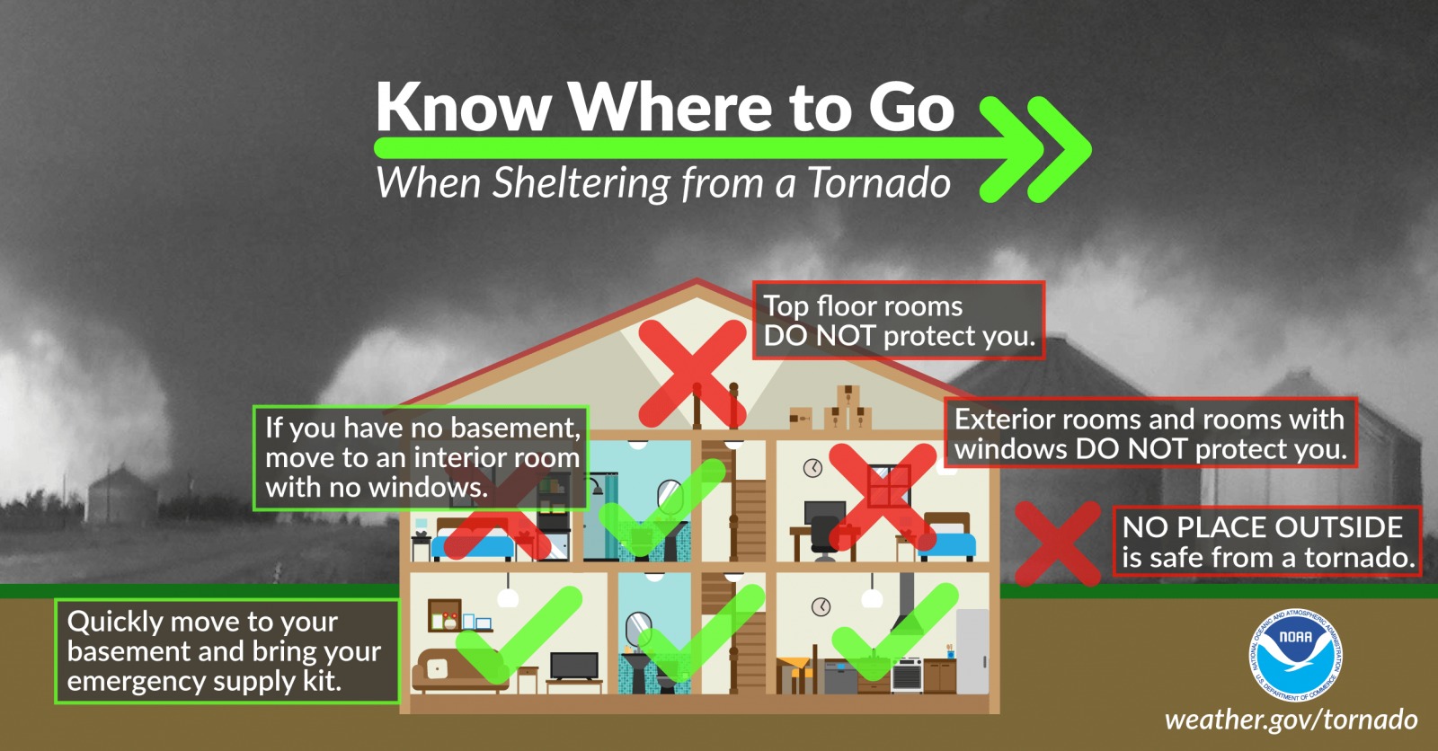
The Marion County Public Safety app from the Marion County Sheriff's Department and EMA includes built-in severe weather notifications for Marion County. These are push notifications that are sent to any mobile phone almost instantly. The app is a great way to receive severe weather notifications, however it is always best to have multiple ways to receive alerts. It is recommended that every household have a NOAA Weather Radio.

NOAA Weather Radio Programming
We have a page dedicated to weather radio programming. See the link below for more information:

STORM SHELTERS
The following is a list of public storm shelters in Marion County. We encourage you to find your closest location BEFORE you need to seek shelter. We also encourage you to reach out to family members who may not have access to this information. Marion County E-911 is not responsible for maintaining any shelters, or for the accuracy of this list. It is made as a courtesy using information available to us. If any corrections or additions need to be made to the list, please email aavery@marion911.net


Also available in Google Maps and downloadable PDF Format
(click the corresponding image above)
Bear Creek
BISHOP COMMUNITY CENTER BASEMENT
Address: 260 High Ave, Bear Creek, AL
GPS: 34.274857, -87.702214 | Capacity: 200
BEHIND BISHOP COMMUNITY CENTER
Address: 252 Sprygler St, Bear Creek, Alabama
GPS: 34.275236, -87.702307 | Capacity: 15
VIRGINIA AVE SHELTER
Address: 237 Virginia Ave, Bear Creek, Alabama
GPS: 34.276014, -87.701430 | Capacity: 48
BEAR CREEK HOUSING AUTHORITY
Address: 8573 State Hwy 13, Bear Creek, Alabama
GPS: 34.278318, -87.699102 | Capacity: 15
Brilliant
BEHIND BRILLIANT CITY HALL
Address: 1279 Main Street, Brilliant, Alabama
GPS: 34.024132, -87.760661 | Capacity: 15
OLD SUNNY HOME FIRE DEPT
Address: 13536 St Hwy 233, Brilliant, Alabama
GPS: 34.083612, -87.698029 | Capacity: 15
Byrd
BYRD FIRE DEPT
Address: 239 County Hwy 13, Detroit, Alabama
GPS: 34.129935,-88.128261 | Capacity: 15
Craft / South Haleyville
CRAFT COMMUNITY CENTER
Address: 7115 County Hwy 19, Haleyville, Alabama
GPS: 34.187448, -87.668711 | Capacity: 15
Guin
DISTRICT 5 SHOP
Address: 441 11th Avenue, Guin, Alabama
GPS: 33.965951, -87.921967 | Capacity: 15
COLLINS LIFE CENTER
Address: 581 14th St, Guin, Alabama
GPS: 33.972942, -87.918231 | Capacity: 200-Handicap Accessible
Hackleburg
HACKLEBURG SCHOOL/COMMUNITY SHELTER
Address: 542 Nix Rd Hackleburg, Alabama
GPS: 34.2814766, -87.8313002 | Capacity: ?
BEHIND HACKLEBURG WATER BOARD
Address: 442 Back Street, Hackleburg, Alabama
GPS: 34.274595, -87.828487 | Capacity: 96-Handicap Accessible
HACKLEBURG HOUSING AUTHORITY, NEAR ENTRANCE
Address: 443 Ray Rd, Hackleburg, Alabama
GPS: 34.285388, -87.820671 | Capacity: 15
HACKLEBURG HOUSING AUTHORITY, NEAR BACK OF COMPLEX
Address: 445 Ray Rd, Hackleburg, Alabama
GPS: 34.2858339, -87.8213741 | Capacity: 15
CO HWY 12 AND GOBER RD
Address: 120 Gober Rd, Hackleburg, Alabama
GPS: 34.267817, -87.816924 | Capacity: 15
WIGINTON COMMUNITY
Address: 4959 County Hwy 32, Hackleburg, Alabama
GPS: 34.283642, -87.875892 | Capacity: 96-Handicap Accessible
Hamilton
BESIDE COUNTY 2 WAY SHOP
Address: 701 4th Ave SW, Hamilton, Alabama
GPS: 34.139720, -87.995557 | Capacity: 48
MARION COUNTY ANNEX [#1 SHELTER]
Address: 372 7th Ave SW, Hamilton, Alabama
GPS: 34.13674, -87.995492
(2) Shelters located here | Capacity: 15 Each
MARION COUNTY ANNEX [#2 SHELTER]
Address: 372 7th Ave SW, Hamilton, Alabama
GPS: 34.13674, -87.995492
(2) Shelters located here | Capacity: 15 each
BEHIND HAMILTON FIRE DEPT
Address: 555 6th St SW, Hamilton, Alabama
GPS: 34.138833, -87.994591 | Capacity: 15
RAGSDALE HOUSING AUTHORITY
690 Bexar Ave E, Hamilton, Alabama
GPS: 34.1410234, -87.977190 | Capacity 96-Handicap Accessible
CHESTNUT CIR HOUSING AUTHORITY
700 Chestnut Circle, Hamilton, Alabama
GPS: 34.158742, -88.015794 | Capacity 96-Handicap Accessible
SULLINS SCHOOL HOUSE (St Hwy 253/Co Hwy 49)
Address: 4509 Co Hwy 49, Hamilton, Alabama
GPS: 34.181111, -87.861175 | Capacity: 15
Hodges
MT. VIEW CHURCH PARSONAGE BASEMENT
Address: 6282 State Hwy 187, Hodges, Alabama
GPS: 34.2821097, -87.9364327 | Capacity: ?
Shottsville / Shiloh
SHOTTSVILLE FIRE DEPT
Address: 396 Co Hwy 56, Hamilton, Alabama
GPS: 34.237417, -88.075054
(2) Shelters Located here | Capacity: 48 & 15
DISTRICT 1 SHOP – SHILOH
Address: 2495 ST HWY 187, Hamilton, Alabama
GPS: 34.24312, -87.936684 | Capacity: 15
CO HWY 25/20 INTERSECTION
Address: 6925 Co Hwy 25, Hamilton, Alabama
GPS: 34.250743, -88.027528 | Capacity: 15
Twin / Pea Ridge
TWIN COMMUNITY CENTER SAFE ROOM
Address: 421 Co Hwy 83, Guin, Alabama
GPS: 34.003090, -87.852477 | Capacity: Approx 30
TWIN TOWN HALL
Address: 6125 St Hwy 253, Guin, Alabama
GPS: 34.003493, -87.857863 | Capacity: 15
PEA RIDGE FIRE DEPT
Address: 5704 Co Hwy 45, Guin, Alabama (Intersection of Co Hwy 42 & Co Hwy 45)
GPS: 34.062155, -87.86751 | Capacity: 15
Winfield
WINFIELD COMMUNITY SAFE ROOM
Address: 126 City Hall St, Winfield, Alabama
GPS: 33.930046, -87.816345 | Capacity: 500-Handicap Accessible
NEAR MEADOWLARK RD & WINDMERE DR
Address: 1316 Meadowlark Rd, Winfield, Alabama
GPS: 33.948727, -87.834039 | Capacity: 15
BESIDE BACCUS VOTING BUILDING
NEAR ROCK CITY CHURCH OF GOD
Address: 5175 County Hwy 38, Winfield, Alabama
GPS: 33.985250, -87.706933 | Capacity: 15